 |
Friday, 19 July, 1996 -- Hiking day
We woke up from the annoying sound of the alarm clock which was set at
06:00. During the following hour we got ready to drive back up to the
Eagle's Nest via the fun hairpin road. We left our belongings in the apartment
so we had light backpacks to carry with only the essentials needed for
the hike to the Kjerag rock. At 07:00 we stood ready to begin the hike.
Henrik tagged along so there were four of us hoping to make it all the
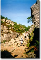
way to Kjeragsbolten. It got pretty steep right away and it felt in the
legs more than we would have thought. We had to stop and catch our breaths
after only ten minutes. It did not look too bad though, we were already
at the same elevation as the Kjerag rock,
|
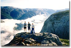
High above the Lysefjord with fog covering
the water below
|
|
|
so we thought we were in for a pretty easy hike. Soon we reached what we
thought would be the "peak" elevation of our hike, but we got
pretty discouraged when we realized that we now had a valley to conquer:
down as much as we had already climbed, and then up even higher on the other
side! Sometimes the climb got so steep that they had put in chains in the
rock so you could use that pull yourself up the mountain. We crossed the
valley and finally reached the next "peak". And what did we see
there? Yes, yet another valley! You feel pretty dispirited when you think
you have reached the top only to find out that the vertical distance you
have climbed up, you will now have to undo by going down again AND up on
the other side once more. The Norwegians have came up with suitable names
for these climbs or "hills" as they like to call them: Wake Up
Hill, Warm Up Hill and Hell Hill. After conquering "Hell Hill"
the surface finally leveled off and we had a much easier hike ahead of us.
We now got close to the edge and We could see a thick fog covering the fjord
below, but we hoped the sun would make it disappear before we reached Kjeragsbolten.
We of course wanted a clear view down to the fjord. After two hours of hiking/climbing
we were finally there. The last few steps before you can take the leap on
to the rock, you will have to negotiate a very narrow (about 4-5 feet) passage
with a vertical rock wall to your right and a 3,280 ft free fall to your
left. With nothing really to hold on to, you are going to literally hug
that wall to
|
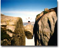
Stefan with trembling legs on the
Kjerag rock
|
|
|
your right, believe me! Having gotten past this last obstacle, you have a bit
more room to build up the courage needed before you jump out on the rock. One
at a time we jumped on to the Kjerag rock, well aware of that if we slip, we
would have a 3,280 ft free fall to look forward to! The fog was still there
blocking the view of the fjord, but maybe that was only a good thing. If we had
been able to see all the way down, it would most likely have been even more
terrifying to make the jump. We took the mandatory pictures of each of us
standing on the rock. Claes and I thought we should also see if two people could
fit on the rock without falling off. We could. :)
The hike back to the Eagle's Nest took the same amount of time as it
took to get to Kjeragsbolten. Logical, since you had to climb up and down
an equal amount no matter which direction you were heading. On our way
back we met several base jumpers who were about to take death defying
leaps off the mountain. A Belgian TV-team were also accompanying one group
as they were going to film these jumpers doing their thing. It looked
pretty exhausting to drag all that camera equipment up there! Before we
got back to Lysebotn we thought it could be a good idea to try make a
reservation on the ferry that would take us out on the Lysefjord, so we
used the cell phone to do this. We found out that if you are traveling
on a motorcycle a reservation was not necessary. Then you just go past
the line of cars waiting to get loaded and park first in line so they
can load the motorcycles first in order to fit as many vehicles as possible.
However, if you are traveling by car you are strongly advised to have
a reservation before you drive down to the small ferry dock, or else you
will most likely have to turn back the same way you came or wait until
the next day, or even longer. The ferry only departs twice a day and during
the summer vacation this is a very popular route.
When we came back down to Lysebotn we picked up our stuff and loaded
it on our bikes before we quickly cleaned the apartment and drove down
to the ferry dock. The line of cars was already long, but we drove past
it and parked first in line, just as we were told. Nice. :) After just
a short wait the ferry arrived and we were soon on our way. We positioned
ourselves on the sun deck so we would get a nice view of the fjord and
the mountain walls to the sides. Now we also got to purchase our tickets.
110 NOK for a motorcycle with driver was a lot more than the regular ferries,
but this was not just a trip to take us from A to B, it was a two and
a half hour sightseeing trip. During the course of the trip a guide used
the onboard speaker system to tell us about things along the fjord. Almost
immediately the ferry positioned itself and came to a halt so we could
see a few base jumpers jump out from Kjerag (the Belgian TV-team). Seeing
it from ground level as we now did it did not really look to be as high
as it really was. But when you see these people jump from the cliff above
you will definitely realize the high altitude from which they are starting
their plunge towards the ground. First all you see is a tiny little dot
"slowly" falling down. After about a ten second free fall they deploy
their parachutes, but at that point they had only fallen about on third
of the total distance! So sure enough they jumped out at a pretty high
altitude. Other things you could see along this route were among other
things seals, the world's longest wooden
|
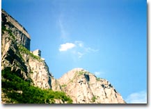
The Pulpit Rock from below
|
|
|
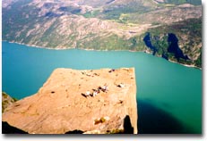
stairway, and the most interesting in my opinion: the Pulpit Rock - or Preikestolen
in Norwegian. This flat mountain plateau towers majestically 2,000 vertical
ft above the Lysefjord. From the Pulpit Lodge (Preikestolhytta) you can
follow a trail climbing 1,150 ft through somewhat uneven terrain until you
reach the Pulpit Rock. This is approximately a two hour hike and if the
weather permits you get a stunning view of the Lysefjord once you reach
Preikestolen. To hike to the Pulpit Rock was of course something we had
planned to do, and luckily the weather today was as perfect as can be.
Around 3:30 PM we arrived at Oanes on the north side of the inlet to the Lysefjord.
Here we got off the ferry and headed towards the Pulpit Lodge. After about 20
minutes we were there and parked our bikes to continue on foot towards the Pulpit
Rock. According to what we had heard the hike to the Pulpit Rock should take no
more than two hours and be fairly easy. But we had heard the same about the hike
to the Kjerag rock as well, and that was far more strenuous than what we had
expected. It would however show to be a big difference between these two hikes.
While the hike to the Kjerag rock was only marked by red painted rocks and went
steeply up and down over barren terrain, the hike to the Pulpit Rock went on a
clearly marked trail at lower altitude so the surroundings were green and lush.
This second hike of the day was not even close to as strenuous as the first one,
even though it went up hill basically all the time. Sometimes you walked on a
regular path, but other times you had to use all four to climb over big rocks or
balance through narrow passageways.
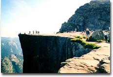
After nearly two hours we were there. The first thing I noticed as the square
shape of the top of the Pulpit Rock appeared in front of me was a guy sitting at
one of the corners with his legs dangling over the edge! Since this was something
I would not do myself, I took out the camera and took a picture so I could show
proof of how crazy some people are.
|
|
The Pulpit Rock - 2,000 ft above the
Lysefjord
|
|
|
We stepped out onto Preikestolen and crossed our fingers hoping the
whole thing would stay where it had been for a few thousand years and
not chose this day to plunge into the water 2,000 ft below. During our
trip through the fjord earlier that same day we had heard about how a
part of the mountain wall not too far away had slid down into the fjord
causing a big wave pushing smaller boats and other things up on the other
side of the fjord. And with a big visible crack at the side connecting
to the mountain, the Pulpit Rock looks like it is made to fall down into
the fjord!
|
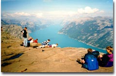
Claes and Niklas peeking over the edge
|
|
|
Not exactly a place where I would like to attend a big rave party, if you know
what I mean. After a while the uncomfortableness from being so high up on a
cliff without any kind of protection other than a sane mind diminished, and we
really started to enjoy the amazing scenery. We slowly but surely moved closer
to the edge and it did take too long before we were lying on our bellies peeking
out over the edge. I can tell you could really feel the height in the stomach!
We stayed on the Pulpit Rock for about an hour enjoying the awesome views and
the nice warm and sunny weather. We would have loved to stay even longer, but we
had a ferry to catch. We had to be back home the next day, but we were still
very far away from home, so we wanted to get a bit further before we stopped for
the night. When we were about ready to begin the hike back down again,
|
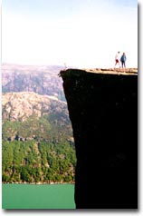
Stefan living on the edge -
literally!
|
|
|
my courage had built up to the extent that I was actually considering sitting
down at that corner with my legs dangling over the edge. That would be the
ultimate feeling, a lot worse than the experience on the Kjerag rock earlier
the same day, because this time you could see all the 2,000 ft down to
the blue green surface of the Lysefjord. So I sat down close to the corner
edge and inched myself closer to the abyss and finally put each leg on each
side of the well defined corner. I motioned to the others to hurry up with
taking pictures, because no matter how stunning the view was or how enormous
the feeling was to sit like this on the very edge, the feeling that this
specific corner would give way to the added weight and fall down into Lysebotn
was even more evident. So I didn't want to hang around longer than necessary.
After I had led the way to crazy land, Niklas, Claes and Henrik one after
the other experienced the same feeling of living on the edge. :) Pleased
with what we had seen and relieved about surviving the adventure on Preikestolen
we hurried back down to our waiting motorcycles. The descent took an hour
and twenty minutes and right before 8 o'clock we were ready to depart. There
was only 15 minutes until the scheduled ferry departure, so we had to rush
things a bit. We said farewell to Henrik who was going to camp nearby, and
then we drove back to Oanes where the ferry would take us south across the
fjord to Lauvvik. We just barely made the ferry.
Over on the south side we how had to get something to eat and find a
place to stay for the night. We kept going south to hit the bigger road
E39. After a while we stopped to eat at a roadside restaurant, but up
to that point we had not seen one single sign about lodging. After this
late dinner we continued southeast on E39. The sun was setting and we
begun to realize that it looked like we would be forced to pitch the tent
somewhere out in the wilderness. So we turned off the main road on to
the smaller road 42 and started looking for a suitable location. After
driving around for about half an hour we found a place that would have
to do since we wanted at least some daylight to be present as we put up
the tent. The location we chose for the tent was just 25 feet or so from
the road, but we didn't have much of a choice. We parked the bikes in
a triangle and put up the tent in the middle. It was close to midnight
when we were done and it was almost pitch black. We got into our sleeping
bags and hoped for a good night's sleep. Although we had a feeling we
would not get much sleep that night. We were right...
|


