We woke up to yet another day of brilliant sunshine and at 10:00 am
we left Strandefjord Camping and Leira, but stopped already in Fagernes.
We had the night before spotted a rather big tourist information there,
so we thought it could be a good idea to use that to inform ourselves
about what possibilities there were to spend the night up on the mountain
range Jotunheimen. And also of course figure out if it was at all possible
to reach the highest peak Galdhøpiggen with the equipment we had
available... ehh... which would be none at all! :)
It seemed like we had two alternatives to choose from: either Juvasshytta
or Spiterstulen. The hike from Juvasshytta was the easiest and shortest
one, but it required some degree of equipment to be used - particularly
a decent pair of hiking boots. And since this route crosses a glacier
you are not allowed to go without an experienced mountain guide. If we
instead chose to start the climb from Spiterstulen, then we could go by
ourselves, but this route would be more physically demanding and it would
take about 5 hours to reach the top. On the other hand no special equipment
was necessary, except for the usual sturdy hiking boots again. We opted
for Spiterstulen and booked a room at the facilities located there.
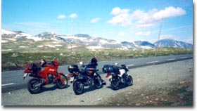
The barren surroundings along road 51 at the eastern
outskirts of Jotunheimen. |
To get there we had to travel around half of the Jotunheimen. Now we
were at the south-east corner of the mountain range, and the road that
leads up to Spiterstulen was at the very north part. So in Fagernes we
turned north onto road 51. And now as we started to get up into higher
terrain, the roads finally became more and more of the sort you expect
to find when touring in Norway. They are narrow, twisting mountain roads
with curve after curve and with most of the time an adorable view out
over the scenery. And the surroundings change a lot too. At lower altitude
you go through dense green vegetation but the higher you get, the more
barren it becomes,
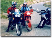
Stefan and Niklas discussing the nice
mountain road ahead. |
and finally you are shown what reminds you of a lunar landscape. We should
now follow road 51 all the way until it ended, which it did about 127
km from Fagernes, where the road changed to no 15 and to an east-west direction.
We turned left and this bigger road lead us at a rapid pace the remaining
26 km towards Lom, a very nice village surrounded with high mountain walls. A
very suitable place to stop for a lunch break!
After a delicious hamburger and a stop to fill up the fuel tanks, we
were on our way again at 3.00 pm. According to the map we now had only
17 km left to the small toll road which would take us from sea level up
to Spiterstulen at an altitude of 1100 meters. This road showed to be
a gravel road in pretty bad shape, so it was a good thing to sit on an
off-road type of bike. If it hadn't been for all the extra load we were
carrying it would have been great fun to drive this road in a more active
way (ie at higher speeds! :). But with all the cattle on the loose around
this road it would probably not have been such a good idea anyway. Since
Claes was the one of us that didn't have the fortune to drive an off-road
bike, he had to stop and adjust the position of his luggage numerous times
as it threatened to glide off his bike. :)
After a few kilometers we arrived at the "toll station". There was no
barrier across the road, only a small sign letting you know that you have
to pay a fee to continue. At first nobody seemed to be interested in receiving
our money, but after a while a guy came out of the nearby house and demanded
15 NOK from each of us. The trip up to Spiterstulen gave us the impression
that this was a road with very little traffic, and because of this we
thought that Spiterstulen would be quite a small and desolate place. An
assumption that could not be more wrong...
It showed to be quite a big place with several buildings containing
200 beds, 2 restaurants, a cafeteria, an indoor pool, conference rooms,
a camping site and a parking space where for sure over 100 cars were already
parked. Spiterstulen is situated 1100 meters above sea level at the tree
line in a beautiful mountain valley and has accepted guests since 1836.
Here you can reach 17 of the 26 norwegian peaks above 2300 meters above
sea level. Needless to say it's a very good starting point if you enjoy
mountain hiking.
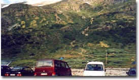
A sight that made us hesitate. |
What struck us most with amazement was not the very nice facilities, but
the huge mountain wall rising on our right side! The amazement soon turned
into dread as we caught sight of very tiny colored dots barely moving up
and down the mountain. Those tiny dots were actually people, and this was
something we should have to conquer to finally reach Galdhøpiggen
at 2469 meters above sea level. It didn't make us feel any better when a
couple of norwegian guys informed us about that when you had climbed as
far as you can see from Spiterstulen, you had only climbed a quarter of
the total distance. Furthermore everybody we could see was wearing real
hiking boots, we only had our jogging shoes! With last year's tough climb
to Kjeragsbolten fresh in our memories, we somewhat discouraged started
to consider a retreat. Maybe it would be better to drive off to the summer
ski center at Juvashytta. Some downhill skiing in the middle of the summer
would be a very nice experience.
No damn it! When we had gotten this far it would be a shame if we didn't
give it a fair try. After some persuading of each other we decided to
stay. The time was now 4.30 pm so it was of course all too late to do
the climb this day. We checked in, got our room and then used the rest
of the evening to recharge and prepare ourselves for the next day's trial
of strength.